The power of effective geospatial information management in South Korea: development and application (2020)

Overview

South Korea has become one of the most successful countries to implement a National Spatial Data Infrastructure (NSDI). Since the Government’s open data policy was adopted in 2013, data has been used from a wide range of end users, including the private and public sectors which has brought about significant growth in the geospatial data market, recording around USD 7 billion of sales revenue in 2018. South Korea is now a benchmark country for its geospatial datasets, technologies and platforms, and capacity development, and is one of the leading countries for Smart Cities in the Asian Continent. In addition, with the successful management of COVID-19, the South Korean data management system is now being exported to other countries.


The study outlines the technical evolution of South Korea’s geospatial information in general then describes the NSDI development plans and strategies, economic impacts on the national market and two cases of the geospatial information application. The analysis concludes with the key factors that contributed to the successful development and application of the National Spatial Data Infrastructure and Information.

Geographical scope

Republic of Korea

Non-quantified impacts

The NSDI has played a key role in providing the integrated development framework for land information systems, as well as other policy, technical, legal, capacity and institutional factors, such as the (i) Open Data Policy, (ii) National Integrated Information System, (iii) extension of fundamental and thematic datasets, and (iv) the presence of strong institutional networks, including by Spatial Information Industry Promotion Institute (SPACE N). Combined, these factors have contributed substantially to the very successful development of the national geospatial data market.


South Korea’s open data policy, mandates that all data, geospatial information data, procured by public institutions and related agencies are free and open to guarantee citizen access rights to public data, thereby contributing to improving their quality of life and to developing the national economy through the utilisation of such public data in the private sector.

Quantifiable impacts

In 2013, the number of available geospatial datasets reached 10,003 – doubling the 5,272 datasets previously available in 2012. This significant increase in data availability realised a rapid growth in the number of mobile applications being developed – 267 were developed within an 8-month period in 2013.


Statistics from 2011 to 2017 released by SPACE N showed a growth in sales revenues from approximately USD 4.5 billion to USD 7.1 billion and an increase in the number of geospatial information industry-related workers from 42,792 to 58,646 (see figure below). That estimate grew again to 63,349 in 2018.
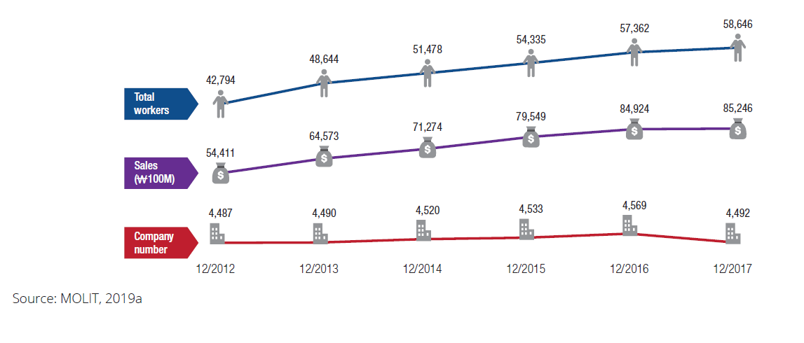


Number of geospatial information-related workers, companies and sales revenue between 2012 and 2017

Reference

Country

Study type

Economic analysis, Estimation of market size

Economy sector

Education, Water, Infrastructure (Transport), Infrastructure (ICT), Infrastructure (Energy), Health, Tourism, Public Safety and Security, Disaster Risk Management, Retail, Finance, Insurance, Real Estate and Land Administration, Design and Construction, Public Sector Local Government, Public Sector Central Government, Maritime, Environment, Agriculture, Geology and Mining, Defence