Economic Valuation of Landsat and Landsat Next 2023 (2024)

Overview

This report undertaken by the Native American Technology Corporation commissioned by the United States Geological Survey (USGS), provides an updated analysis of the economic benefits of Landsat satellite imagery and projects the additional value expected from the Landsat Next mission.


The Landsat Program (first launched in 1972) is a series of Earth-observing satellite missions jointly managed by the National Aeronautics and Space Administration (NASA) and the USGS.  Landsat is the only U.S. satellite system designed to collect essential data on the Earth’s geological formations, natural habitats, farmlands, cities, lakes, glaciers, coastlines and other surface features. Landsat satellites provide imagery at landscape-scale resolution that can be used to document land change due to climate change, urbanization, drought, wildfire, biomass changes (carbon assessments), and other natural and human-caused changes. The program aims to improve environmental sustainability, climate change resiliency, and economic growth whilst also recording an unparalleled record of the Earth’s changing landscapes.


The study quantifies the economic value of the program to direct and indirect users, including cost savings for government agencies and commercial benefits. The report also evaluates the incremental benefits of Landsat Next (the multi-spectral trio of satellites scheduled to launch in the early 2030s), and projects its potential increase in value due to its enhanced capabilities compared to current Landsat satellites.

Geographical scope

Global

Non-quantified impacts

The report details many Landsat benefits that are difficult to quantify in monetary value.  These include:

  • measuring carbon emissions
  • analysing how wetlands and lakes benefit people
  • estimating agricultural water use
  • tracking biodiversity and wildlife
  • monitoring deforestation
  • gauging economic activity and urban growth


Quantifiable impacts

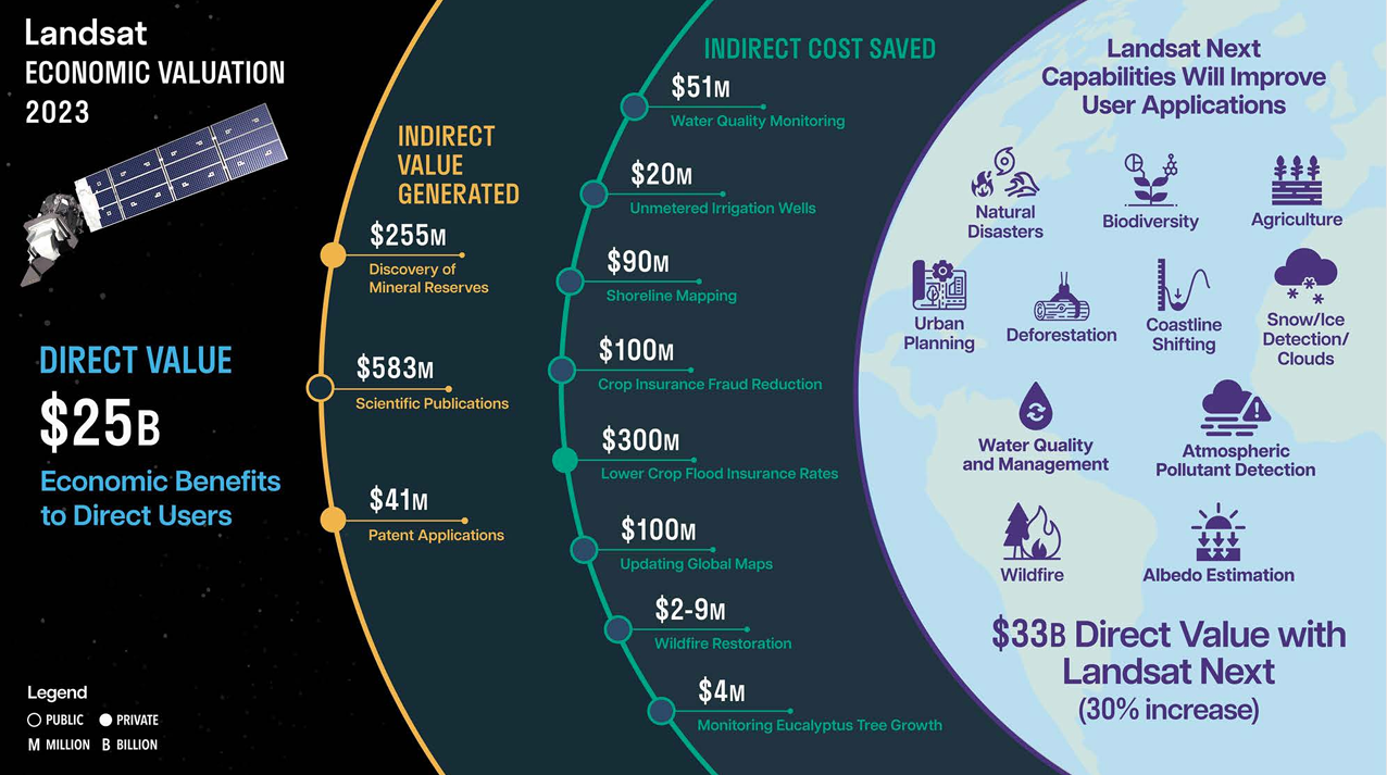
The report estimates that the total value of Landsat imagery accessed in 2023 to be USD 25.63 billion – a marked increase from its 2017 estimate of USD 3.45 billion.


The study estimates the potential benefits across sectors resulting from improved Landsat Next observations to be between USD 33.3 billion and USD 34.7 billion annually, representing a 30-35 percent increase in value per scene (an image captured by the Landsat satellites, each scene covers an area of approximately 185 kilometres by 185 kilometres). These figures were based on the number of downloaded scenes from 2023, which came to 65.5 million. Given the 10-year trend of increased use of Landsat data, the total economic value can be expected to grow beyond the nearly USD 35 billion.


Summary infographic of Landsat economic valuation 2023


Sources/Usage: USGS/Public Domain


The driving force behind Landsat’s dramatic gain in total value is the increase in scene-equivalent imagery accessed by users, estimated at 18.1 million in 2017 and rising to 65.6 million in 2023. This figure was derived by measuring the total volume of Landsat data accessed through both computer downloads and cloud-based usage, and then dividing it by the average size of a Landsat scene.


Landsat use has continued to increase over the years, due to the landmark 2008 decision by the USGS to make Landsat data available at no cost to users. In 2020, this was enhanced by the availability of Landsat data in the cloud which further improved access by enabling faster downloads and analysis, reducing latency and increasing availability for users worldwide.


Reference

Country

Study type

Economic analysis, Willingness to Pay (WTP), Contingent Valuation Method (CVM)

Economy sector

Education, Water, Infrastructure (Transport), Infrastructure (ICT), Infrastructure (Energy), Tourism, Public Safety and Security, Disaster Risk Management, Finance, Insurance, Real Estate and Land Administration, Design and Construction, Public Sector Local Government, Public Sector Central Government, Maritime, Environment, Agriculture, Defence, Meteorology