Economic impact of geospatial services in Australia (2024)

Overview

This study commissioned by the Geospatial Council of Australia (GCA) and carried out by ACIL Allen, examines the Australian geospatial industry’s current value and also its potential impact on the Australian economy in 2034. The study builds upon a previous assessment conducted in 2008.


The assessment of Geospatial information comprises all information with a location. The geospatial sector describes the organisations and professionals that acquire, integrate, manage, analyse, map, distribute, and use geographic, temporal, and geospatial information and knowledge.


The study highlights the critical role of geospatial information in enhancing national productivity and shows its significant direct economic impact on Australia’s economy. Furthermore, it seeks to explore opportunities for expanding its potential usage for further societal benefit.

Geographical scope

Australia

Non-quantified impacts

The study has sought to capture some of the various societal benefits from the day-to-day use of geospatial information, such as tackling climate change, environmental management, sustainability and emissions reduction monitoring, resilience planning, emergency and national disaster response and management, along with defence and security. As some of these impacts of geospatial can be difficult to quantify and monetize, these are articulated in a series of sector-based case studies that showcase how geospatial services add value across the Australian economy.

The case studies include:

  • Emergency services – the Tasmanian State Emergency Services use a real-time satellite early warning system that results in much faster response times.
  • Bathymetry (seabed mapping) – Port Hedland, a major iron ore port in Western Australia, uses a Hydroid (a model to better understand sea levels and depths of a particular area) to gain considerable improvements to the port’s productivity.
  • Biosecurity – a Red Imported Fire Ants (RIFA) Eradication Program is being supported by geospatial information and artificial intelligence to reduce the spread of RIFA.
  • Managing climate and natural resources – once established, a Shared Environmental Analytics Facility (SEAF) in Western Australia, would be an innovative data analytics facility to create a sustainable environmental value chain.
  • Consumers – to reduce future traffic congestion from Connected Autonomous Vehicles (CAVs) governments in Australia are looking at the use of Cooperative Intelligent Transport Systems (C-ITS) and the benefits of Satellite-Based Augmentation Systems (SBAS) signals which can improve the accuracy of vehicle positioning, enabling better demand management options such as real-time road pricing.
  • Foundation Spatial Data Framework (FSD) – the New South Wales FSD provides geospatial infrastructure of authoritative foundational spatial data to support government services and national collaboration.
  • Land and project development – Victoria’s Digital Cadastre Modernisation (DCM) and Digital Transformation Program has helped to address a series of challenges to the existing cadastral mapping such as defining quality measures for output data, developing highly automated multistage processing, and delivering quality assurance verification into the production process.


Each case study highlights how industry make use of a range of geospatial services across sectors and deliver impact to a broad range of end-users and beneficiaries. The URL for the case study companion report which includes 65 sectoral examples is included in the references section.

Quantifiable impacts

Key findings:


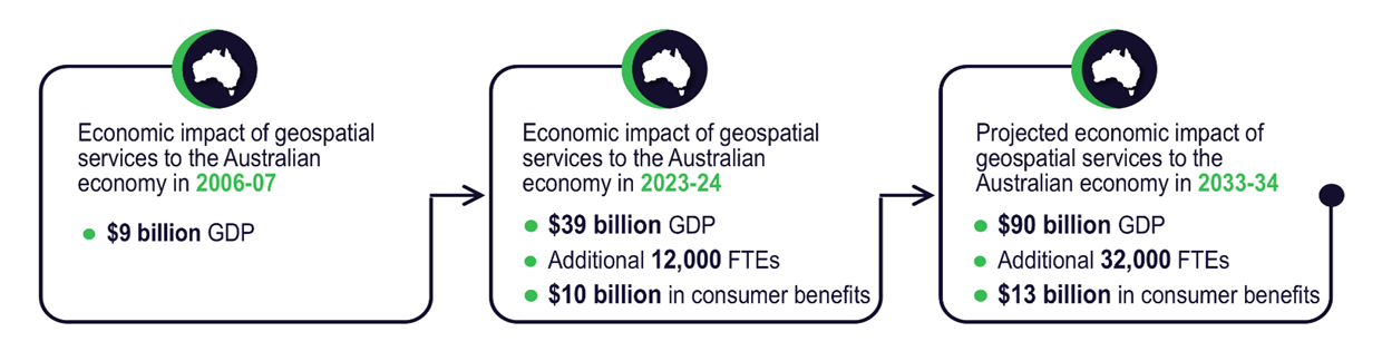
The sector in 2023-24 will contribute an additional AUD 39 billion to Australian GDP and over 12,000 jobs. By 2033-34, it is projected that the contribution could be an additional AUD 90 billion in GDP, and an additional 32,000 jobs, assuming a favourable operating scenario.


Summary of impact under a favourable operating scenario

Source: GCA / ACIL Allen


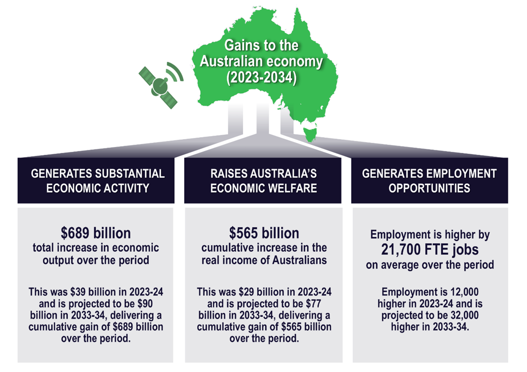
Over the next decade, the economic impacts in terms of economic activity, economic welfare and the employment opportunities generated are significant (see figure below). The undiscounted impact on economic output is projected to be AUD 689 billion over the period and the impact on real income is projected to be AUD 565 billion over the same period. Employment is projected to be higher by 21,700 FTE jobs on average over the period.


Summary of gains to the Australian economy (2023 – 2034)

Source: GCA / ACIL Allen


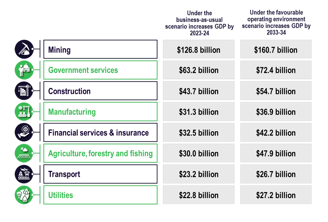
The total impact on output for selected sectors over the 2023-24 to 2033-34 period is summarised in the figure below. The largest impact over the period occurs in the mining sector where output is projected to be AUD 161 billion higher that it would have otherwise been without modern geospatial data services. Over the same period, the increase is AUD 72 billion for government, AUD 55 billion for construction, AUD 42 billion for financial services and insurance and AUD 48 billion for agriculture, fisheries and forestry.


Summary of impact on industries

Source: GCA / ACIL Allen

Reference

Find this article at:

https://acilallen.com.au/projects/geospatial/economic-impact-of-geospatial-services-in-australia

A companion report featuring 65 case studies can be accessed using the same link above.

Country

Study type

Economic analysis, Case studies, Computable General Equilibrium (CGE) model

Economy sector

Education, Water, Infrastructure (Transport), Infrastructure (ICT), Infrastructure (Energy), Health, Tourism, Public Safety and Security, Disaster Risk Management, Retail, Finance, Insurance, Real Estate and Land Administration, Design and Construction, Public Sector Local Government, Public Sector Central Government, Maritime, Environment, Agriculture, Geology and Mining, Defence, Meteorology